Rain Scatter: Difference between revisions
Jump to navigation
Jump to search
Created page with "One of new feature (2016) in Tucnak is Rain Scatter map. It merges data from public rain radars and shows it in map. Image:Rainscatter.png|thumb|none|..." |
No edit summary |
||
| Line 1: | Line 1: | ||
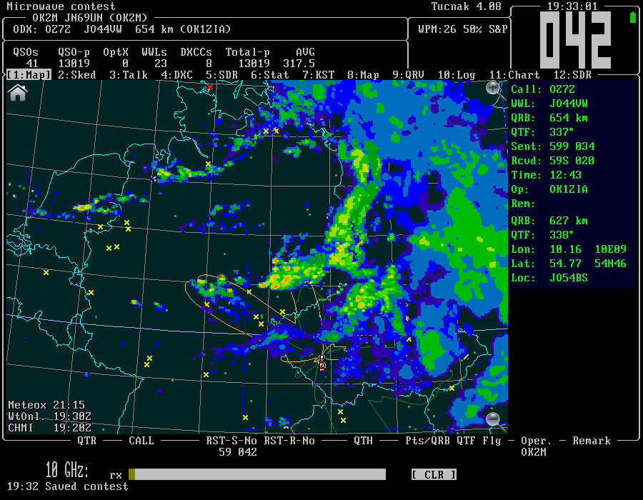
One of new feature (2016) in Tucnak is Rain Scatter map. It merges data from public rain radars and shows it in [[Subwin_types#Map|map]]. | One of new feature (2016) in Tucnak is Rain Scatter map. It merges data from public rain radars and shows it in [[Subwin_types#Map|map]]. Merge means that palette of images is unified, higher rain intensity is painted on the top. If some rain provider is delayed, Tucnak loads latest available image. | ||
[[Image:Rainscatter.png|thumb|none|900px|Rain Scatter map in Tucnak]] | [[Image:Rainscatter.png|thumb|none|900px|Rain Scatter map in Tucnak]] | ||
The time in the left bottom corner is date of displayed image for all providers. If red, Tucnak was not able to load the image. In this case clouds are displayed in greyscale to inform operator. | |||
=Options= | |||
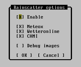
Settings is in dialog Rainscatter options: | Settings is in dialog Rainscatter options: | ||
[[Image:Rainscatter_options.png|thumb|none|900px|Rain Scatter Options]] | [[Image:Rainscatter_options.png|thumb|none|900px|Rain Scatter Options]] | ||
* '''Enable:''' - enable or disable the rain subsystem | |||
* '''Meteox:''' - load data from meteox.com. It covers area from G to OK. Displays time in CE(S)T. | |||
* '''Wetteronline:''' - load data from wetteronline.de. Covers area form 0th longitude to west UR. It cannot be delayed, I think it returns prognose in this case. | |||
* '''Debug:''' - shows pixels instead of filled areas. Good for mapping image to land by border compare. Also saves temporary images into current directory. | |||
=How to operate= | |||
Look for high intensity rain. The palette is here: [Image:Rainscatter_palette.png]. | |||
Revision as of 19:53, 8 July 2016
One of new feature (2016) in Tucnak is Rain Scatter map. It merges data from public rain radars and shows it in map. Merge means that palette of images is unified, higher rain intensity is painted on the top. If some rain provider is delayed, Tucnak loads latest available image.

The time in the left bottom corner is date of displayed image for all providers. If red, Tucnak was not able to load the image. In this case clouds are displayed in greyscale to inform operator.
Options
Settings is in dialog Rainscatter options:

- Enable: - enable or disable the rain subsystem
- Meteox: - load data from meteox.com. It covers area from G to OK. Displays time in CE(S)T.
- Wetteronline: - load data from wetteronline.de. Covers area form 0th longitude to west UR. It cannot be delayed, I think it returns prognose in this case.
- Debug: - shows pixels instead of filled areas. Good for mapping image to land by border compare. Also saves temporary images into current directory.
How to operate
Look for high intensity rain. The palette is here: [Image:Rainscatter_palette.png].